Showing 212 items matching tourist map
-
 Marysville & District Historical Society
Map (Item) - Tourist Map, Tourists Resorts' Committee, Tourist's Map of Healesville Marysville and Warburton Districts, 13.10.1925
... Tourist Map...tourist map...A tourist map for Healesville, Marysville and Warburton...A tourist map for Healesville, Marysville and Warburton...A tourist map for Healesville, Marysville and Warburton ...A tourist map for Healesville, Marysville and Warburton that was produced by the Tourists Resorts' Committee. This map was produced in 1925.A tourist map for Healesville, Marysville and Warburton that was produced by the Tourists Resorts' Committee.Photo Lithographed at the Department of Lands and Survey, Melbourne by W.J. Butson./ 13.10.25healesville, marysville, warburton, victoria, tourists resorts' committee, ben cairn, mount donna buang, the black's spur, the acheron valley, narbethong, launching place, tourist information, tourism, map, tourist map -
 Marysville & District Historical Society
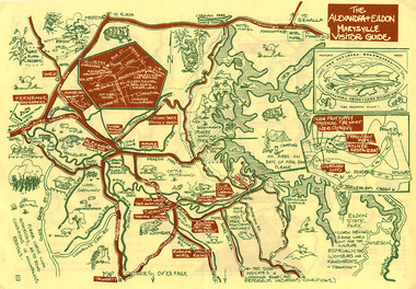
Map (Item) - Tourist map, The Alexandra and Eildon Standard, THE ALEXANDRA & EILDON MARYSVILLE VISITOR GUIDE, 1997
... Tourist map...tourist map...A tourist map for the Alexandra, Eildon and Marysville...A tourist map for the Alexandra, Eildon and Marysville...A tourist map for the Alexandra, Eildon and Marysville ...A tourist map for the Alexandra, Eildon and Marysville region that was produced by the Alexandra and Eildon Standard newspaper. This tourist map was produced in 1997.A tourist map for the Alexandra, Eildon and Marysville region that was produced by the Alexandra and Eildon Standard newspaper.c 1997/ PUBLISHED BY/ THE ALEXANDRA/ AND EILDON/ STANDARD./ GRAPHICS/ BY THE T.T.S./ EILDON.alexandra, eildon, marysville, victoria, australia, tourist map, alexandra & eildon standard -
 Marysville & District Historical Society
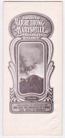
Map (Item) - Tourist Map, Department of Lands & Survey, Tourist's Map of Narbethong and Marysville Districts Victoria, 1913
... Tourist Map...tourist map...A tourist map for the Narbethong and Marysville Districts...A tourist map for the Narbethong and Marysville Districts...A tourist map for the Narbethong and Marysville Districts ...A tourist map for the Narbethong and Marysville Districts that was originally produced by the Department of Lands & Survey in 1925.A tourist map for the Narbethong and Marysville Districts that was originally produced by the Department of Lands & Survey in 1925.Reprint of the 1925 Tourist brochure by permission R.E. Holmes Surveyor General By Authority: ALBERT J. MULLETT, Government Printer, Melbourne. Photo Lithographed at the Department of Lands and Survey Melbourne by W.J. Butson/ 26.8.13narbethong, marysville, victoria, department of lands & survey, the acheron valley, warburton, map, tourist map -
 Marysville & District Historical Society
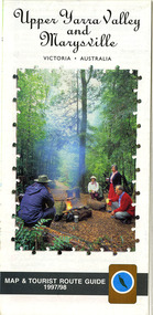
Map (Item) - Tourist map and guide, Warburton Ranges Tourism, Upper Yarra Valley and Marysville VICTORIA-AUSTRALIA, 1997
... Tourist map and guide....tourist map...A tourist map and guide for the Upper Yarra Valley...A tourist map and guide for the Upper Yarra Valley...A tourist map and guide for the Upper Yarra Valley ...A tourist map and guide for the Upper Yarra Valley and Marysville produced by Warburton Ranges Tourism and Mystic Mountains Tourism in 1997.A tourist map and guide for the Upper Yarra Valley and Marysville produced by Warburton Ranges Tourism and Mystic Mountains Tourism in 1997.marysville, victoria, australia, tourist map, tourist guide, mystic mountains tourism, warburton ranges tourism, lake mountain, marysville post shop, the marysville museum, bruno's art and sculpture garden, marylands country house, blackwood cottages, dalrymples guest cottages, anastasia's cottage, marysville hotel motel, kerami guest house, the cumberland -
 Marysville & District Historical Society
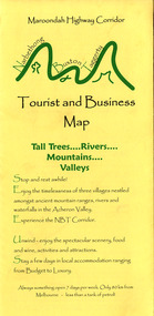
Map (Item) - Tourist and business map, Narbethong Community and Tourism Group, Narbethong Buxton Taggerty Tourist and Business Map, 04-2008
... Tourist and business map...Narbethong Buxton Taggerty Tourist and Business Map...tourist and business map...A tourist and business map of Narbethong, Buxton...A tourist and business map of Narbethong, Buxton...A tourist and business map of Narbethong, Buxton ...A tourist and business map of Narbethong, Buxton and Taggerty. This map was produced by the Narbethong Community and Tourism Group in April 2008. It was produced to promote the natural attractions, adventure activities and food trail from the Black Spur, through Narbethong, Buxton and Taggerty.A tourist and business map of Narbethong, Buxton and Taggerty.This publication has been produced by the Narbethong Community and Tourism/ Group (NCTG) to promote the natural attractions, adventure activities and food/ trail from the Black Spur, through Narbethong, Buxton and Taggerty./ the information provided in this publication has been supplied by the individual/ members. NCTG takes no responsibility for its accuracy./ April 2008narbethong, buxton, taggerty, victoria, australia, tourist and business map, narbethong community and tourism group, acheron valley, yarra track, wood's point, black spur, mystic mountains, the meeting of the waters, cathedral range, danico design counted cross stitch, things of sand & stone, buxton zoo nursery & oddz & enz, willowbank at taggerty, safe trek 4wd services, pnl 4wdriving, buxton trout and salmon farm, mystic mountains ski hire & outdoors, narbethong ski hire, highwood health centre, cathedral view natural therapies, narby cabinets, plants by shelian, gb timber, executive signs, rb automotive repairs, buxton car care, marysville towing & equipment hire, martyn slade building design, cathedral peak framing, black spur roadhouse & ski hire, tudor lodge roadhouse & ski hire, buxton roadhouse & persian bazzar, buxton post office general store & niche bar, igloo roadhouse, taggerty store, narby eggs, marapana agistment park, mantirri blueberry farm, carmyle farm, hazelwood hazelnuts, south cathedral lavender farm, cathedral cherries, black spur motel & caravan park, woodlands rainforest retreat, chestnut glade, black spur inn, wombat cottage, abbey lake luxury b & b spa cottages, blue views holiday cottages, camp narbethong, marapana farm stay b & b, mantirri blueberry farm b & b, little dene garden cottages, silverstream b & b cottages, nareen cabins, moondai farm b & b, south cathedral farm luxury b & b cottages, yarrolyn caravan park, sarsens rest, lomah retreat, pinjarra gardens, kingbilli country estate, henry viii manor house, buxton hotel, butters cafe of buxton, wagtail wines, little river wines, lanterns at willowbank, wirrawilla rainforest walk, wilhemina falls, the cascades -
 Marysville & District Historical Society
Map (Item) - Tourist and business map, Narbethong Community and Tourism Group, Narbethong Buxton Taggerty Tourist and Business Map, 04-2008
... Tourist and business map...Narbethong Buxton Taggerty Tourist and Business Map...tourist and business map...A tourist and business map of Narbethong, Buxton...A tourist and business map of Narbethong, Buxton...A tourist and business map of Narbethong, Buxton ...A tourist and business map of Narbethong, Buxton and Taggerty. This map was produced by the Narbethong Community and Tourism Group in April 2008. It was produced to promote the natural attractions, adventure activities and food trail from the Black Spur, through Narbethong, Buxton and Taggerty.A tourist and business map of Narbethong, Buxton and Taggerty.This publication has been produced by the Narbethong Community and Tourism/ Group (NCTG) to promote the natural attractions, adventure activities and food/ trail from the Black Spur, through Narbethong, Buxton and Taggerty./ the information provided in this publication has been supplied by the individual/ members. NCTG takes no responsibility for its accuracy./ April 2008narbethong, buxton, taggerty, victoria, australia, tourist and business map, narbethong community and tourism group, acheron valley, yarra track, wood's point, black spur, mystic mountains, the meeting of the waters, cathedral range, danico design counted cross stitch, things of sand & stone, buxton zoo nursery & oddz & enz, willowbank at taggerty, safe trek 4wd services, pnl 4wdriving, buxton trout and salmon farm, mystic mountains ski hire & outdoors, narbethong ski hire, highwood health centre, cathedral view natural therapies, narby cabinets, plants by shelian, gb timber, executive signs, rb automotive repairs, buxton car care, marysville towing & equipment hire, martyn slade building design, cathedral peak framing, black spur roadhouse & ski hire, tudor lodge roadhouse & ski hire, buxton roadhouse & persian bazzar, buxton post office general store & niche bar, igloo roadhouse, taggerty store, narby eggs, marapana agistment park, mantirri blueberry farm, carmyle farm, hazelwood hazelnuts, south cathedral lavender farm, cathedral cherries, black spur motel & caravan park, woodlands rainforest retreat, chestnut glade, black spur inn, wombat cottage, abbey lake luxury b & b spa cottages, blue views holiday cottages, camp narbethong, marapana farm stay b & b, mantirri blueberry farm b & b, little dene garden cottages, silverstream b & b cottages, nareen cabins, moondai farm b & b, south cathedral farm luxury b & b cottages, yarrolyn caravan park, sarsens rest, lomah retreat, pinjarra gardens, kingbilli country estate, henry viii manor house, buxton hotel, butters cafe of buxton, wagtail wines, little river wines, lanterns at willowbank, wirrawilla rainforest walk, wilhemina falls, the cascades -
 Whitehorse Historical Society Inc.
Photograph, Launch of Valley of the Arts Tourist Map, 1/10/2000 12:00:00 AM
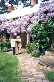
... Launch of Valley of the Arts Tourist Map... Committee speaking at the launch of the Valley of the Arts Tourists... of the Arts Tourist Map Coloured Photo of President of the Valley ...Coloured Photo of President of the Valley of the Arts Committee speaking at the launch of the Valley of the Arts Tourists Map at Schwerkolt Cottage.valley of the arts, schwerkolt -
 Warrnambool and District Historical Society Inc.
Advertising, Tourist Map of Warrnambool (framed x 2), 1950s
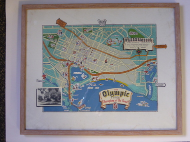
... Tourist Map of Warrnambool (framed x 2)...These framed tourist maps came from the Lane Foundation so...This is a tourist map of the Warrnambool C.B.D... Advertising Tourist Map of Warrnambool (framed x 2) This is a tourist ...These framed tourist maps came from the Lane Foundation so it is presumed that they were from the office of Lane’s Travel Service which operated from 205 Raglan Parade Warrnambool with the known dates, the 1950s and 1960s. The proprietor, Alan Lane, was a successful Warrnambool businessman who operated a Warrnambool and district bus service as well as his travel business. He was heavily involved in local community affairs being a Warrnambool Councillor for 18 years from 1952 to 1970 and President of the Warrnambool Chamber of Commerce for six years. He was a major donor to the Warrnambool Performing Arts Centre, the Warrnambool Art Gallery and the St. John of God Hospital and left the bulk of his estate to the Alan Lane Foundation which has contributed millions of dollars to local organizations and programs. Alan Lane died in 1995. These framed maps are of some interest as examples of the tourism maps used to promote the city and district in the 1950s and 60s. This is a tourist map of the Warrnambool C.B.D. and adjoining streets produced as an advertisement for Olympic Tyres. It is multi-coloured and has cartoon sketches of the main tourist attractions and pointers to attractions outside of the main city area. It includes an inset black and white photograph of the Warrnambool Botanic Gardens and an advertisement for Olympic Tyres. It is printed on a white background and is enclosed behind glass in a wooden frame of a light brown colour. It has a wire at the back for attachment to a wall. ‘Warrnambool – 163 miles from Melbourne – a popular tourist resort offering many holiday attractions – an ideal surfing beach with all modern facilities is avalable’ ‘Fit Olympic Tyres, Champions of the Road’ alan lane foundation, warrnambool tourism -
 Whitehorse Historical Society Inc.
Photograph, Launch of Valley of the Arts Tourist Map, 1/10/2000 12:00:00 AM
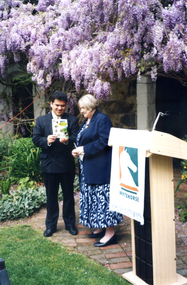
... Launch of Valley of the Arts Tourist Map... of the Arts Tourist Map at Schwerkolt Cottage on 6 October 2000.... of the Arts Tourist Map Coloured photo of Chief Executive Officer ...Coloured photo of Chief Executive Officer of City of Whitehorse, Noelene Duff, speaking at the launch of the Valley of the Arts Tourist Map at Schwerkolt Cottage on 6 October 2000.city of whitehorse, duff, noelene, valley of the arts, schwerkolt cottage -
 Whitehorse Historical Society Inc.
Photograph, Launch of Valley of the Arts Tourist Map, 1/10/2000 12:00:00 AM
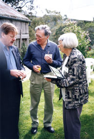
... Launch of Valley of the Arts Tourist Map... of the Arts Tourists Map at Schwerkolt Cottage on 6 October 2000.... of the Arts Tourist Map Coloured photo of Bruce Atkinson, M.L.C., Ted ...Coloured photo of Bruce Atkinson, M.L.C., Ted and Valda Arrowsmith (President of Society) at the launch of the Valley of the Arts Tourists Map at Schwerkolt Cottage on 6 October 2000.victoria.legislative council. koonung province, atkinson, bruce, arrowsmith, ted, valda -
 Whitehorse Historical Society Inc.
Photograph, Launch of Valley of the Arts Tourist Map, 1/10/2000 12:00:00 AM
... Launch of Valley of the Arts Tourist Map... of Co-operative venture Valley of the Arts Tourist Map... of the Arts Tourist Map Coloured photo of Minister for Tourism, John ...Coloured photo of Minister for Tourism, John Pandazopoulos and Mayor of City of Whitehorse, Cr, Jessie MacCallum at launch of Co-operative venture Valley of the Arts Tourist Map at Schwerkolt Cottage on 6th October 2000.pandazopoulos, john, maccallum. jessie, city of whitehorse, valley of the arts, schwerkolt cottage. -
 Robin Boyd Foundation
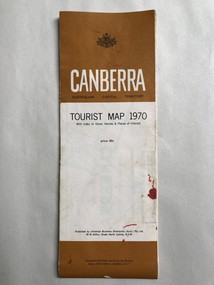
Map, Universal Business Directories, Canberra Tourist Map, 1970
... Canberra Tourist Map... melbourne Map Canberra Tourist Map Walsh St library Universal ...walsh st library -
 Ringwood and District Historical Society
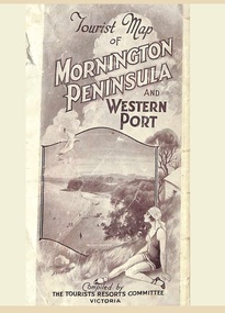
Memorabilia, Tourist Map of Mornington Peninsula and Western Port - 1929
... Tourist Map of Mornington Peninsula and Western Port - 1929... by details of main features and points of interest. Tourist Map ...Multi-fold pictorial map of towns, railways and main roads east of Port Phillip Bay from Melbourne to Yarra Junction and south to Phillip Island and Wonthaggi, backed by details of main features and points of interest.Photo-Lithographed by Department of Lands and Survey, Melbourne, 2.8.1929. -
 Glenelg Shire Council Cultural Collection
Map - Fold-out Tourist Map of Portland and District, n.d
... Fold-out Tourist Map of Portland and District... Cliff Street Portland great-ocean-road Fold-out Tourist Map ...Black and white fold-out map of Portland District. reverse has maps of Portland and Mt. Gambier, plus tourist information about points of interest in both towns. When folded, photo of Cape Nelson lighthouse on front. -
Warrnambool and District Historical Society Inc.
Pamphlet - Tourist Map and Guide, Victorian Railway Commissioners, Warrnambool Victoria Australia, c. 1950
... Tourist Map and Guide... Warrnambool Rail Warrnambool Tourist Guides Warrnambool Tourist Map ...Warrnambool Tourist Map and Guide.1 This is a single sheet of paper folded twice to make a pamphlet. It has a multi-coloured map (predominantly yellow), an illustration, several black and white photographs, printed text and coloured headings. .2 This is a single sheet of paper inserted into item 1. It is folded twice and contains black and white photographs.non-fictionWarrnambool Tourist Map and Guidetourism in warrnambool, warrnambool rail, warrnambool tourist guides -
Marysville & District Historical Society
Flyer (item) - Brochure, Artworkz Tourism, Marysville-Steavenson Falls, 2018
... A brochure including photographs and a tourist map...A brochure including photographs and a tourist map... and a tourist map of Marysville and some of the area's attractions ...A brochure including photographs and a tourist map of Marysville and some of the area's attractions focusing on Steavenson Falls. A brochure including photographs and a tourist map of Marysville and some of the area's attractions focusing on Steavenson Falls. The Steavenson Falls is named after the Victorian Assistant Commissioner of Roads and Bridges, John Steavenson who arrived in Victoria in the early 1860s.Shadowed by over 30 Mountains and/ on the banks of the beautiful Goulburn River/ and Lake Eildon. This is our playground.marysville, steavenson falls, victoria, waterfalls, john steavenson -
 Bendigo Military Museum
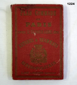
Plan - MAP, TOURIST, L Joly, A Maunier, WWI
... MAP, TOURIST..., folded paper map attached to back cover. Plan MAP, TOURIST L Joly ...The map belonged to Jack Grinton No 1043 38th Batt AIF. At Wars end extensive leave was granted, Jack journeyed to Paris, Nice, Monte Carlo taking many photos. Part of the Grinton collection which included hundreds of negatives and developed photos that he took during the War. Refer Cat No 1280 for service details. Refer 1317P, 1320P.Map of Paris. Red cardboard or paper hardcover, new edition guide of metropolitan Paris (ministries, tramways, monuments), Index in front, folded paper map attached to back cover. "Plan commode de Paris avec l'itineraire des autobus & tramways metropolitan"documents-maps, french -
Stawell Historical Society Inc
Map, 1928
... Tourist Map of Grampians/Halls Gap and Surrounds... grampians Map Tourist Map of Grampians/Halls Gap and Surrounds ...Tourist Map of Grampians/Halls Gap and Surroundsstawell, tourism -
Clunes Museum
Pamphlet, Wilkins Tourist Maps
... Tourist Map... and surrounds with points of interest. Tourist Map Day Tours of Clunes ...Colour Clunes area map outlining day tours around Clunes and surrounds with points of interest.tourist map, day tours of clunes -
 Marysville & District Historical Society
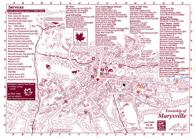
Map (Item) - Information map, Michael Hampton, 2000
... tourist map... of the township of Marysville. marysville victoria australia tourist map ...An information map of the township of Marysville. This map was produced by McNamara Country Real Estate in 2000. The artist who drew the map was named Michael Hampton.An information map of the township of Marysville.MICHAEL HAMPTON/ 2000 VERSION 1:2/ 01/01marysville, victoria, australia, tourist map, information map, mcnamara country real estate, michael hampton -
Whitehorse Historical Society Inc.
Document, Melbourne's Valley of the Arts, 2002
... Tourism Newsletter Jan 2002 Tourist attractions Map Map, brochure ...Map, brochure and copy of 'Melbourne's Valley of the Arts Tourism Newsletter Jan 2002Map, brochure and copy of 'Melbourne's Valley of the Arts Tourism Newsletter Jan 2002Map, brochure and copy of 'Melbourne's Valley of the Arts Tourism Newsletter Jan 2002tourist attractions, map -
 Ballarat Tramway Museum
Map, Melbourne and Metropolitan Tramways Board (MMTB), "MMTB Map of Melbourne Tramways 1934-5", 1934
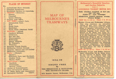
... tramways MMTB Map MMTB Timetables Tourist Trips Map Very small ...Demonstrates methods of giving information to visitors to Melbourne and yields information about tram services at the time in Melbourne.Very small pocket sized timetable and map book, consisting of 2 octavo cards stapled and folded into 12 pages consisting of three pages of bus and tram round trips, 3 center pages for map of electric and cable trams, route numbers and interest points. Map printed in 4 colours. 4 pages index to routes and first and last trams to City and from City. Also gives points where suburban routes are intersected by City routes. One page devoted to places of interest. All printing in black with red headings and highlights.trams, tramways, mmtb map, mmtb, timetables, tourist trips, map -
 Mission to Seafarers Victoria
Map - Street Map, Port de Papeete Tahiti
... Tourist map of the streets of Port de Papeete, Tahiti... melbourne Street Map Map Port de Papeete Tahiti Tourist map ...Several items were given by a seafarer, Mr Nicholas Garlick (1926-2009) into the care of Father Brady who retired from St Pauls Cathedral, Melbourne in 2018. Father Brady later donated the collection of; objects, documents and an extensive collection of cruise ship menus (1937-end of 20thC) to the Mission via the intermediary William Hastie, volunteer at the Mission for Seafarers.Tourist map of the streets of Port de Papeete, Tahiti printed in greenish-grey ink on thin ochre coloured cardboard. Produced for Hertz rent a car (see media). port de papeete, tahiti, hertz, nick garlick, nicholas garlick, father brady, william hastie, ship engineer, sailors, seamen, seafarers -
 Lara RSL Sub Branch
Photograph The Kokoda Trail - "Courage, Mateship, Sacrifice, Endurance", Kokoda Trail - "Courage, Mateship, Sacrifice, Endurance"
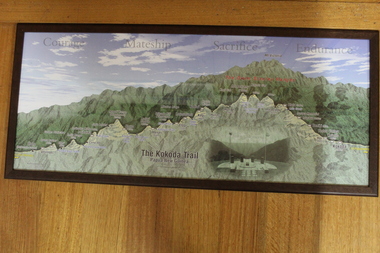
... Tourist map of the Kokoda Trail, Owen Stanly Ranges - IIolo... Village. None Tourist map of the Kokoda Trail, Owen Stanly Ranges ...Tourist map of the Kokoda Trail, Owen Stanly Ranges - IIolo to Kokoda, Papua to New GuineaGraphical map of the Kokoda TrailPicture Kokoda Trail - Papua New Guinea - Owen Stanley Ranges showing a cut through to emphasize the variation in height in the Ranges, with left to right of the villages and townships that represent the trail. Also contains an inset picture of the Memorial at Isurava Village.Nonekokoda trail, owen stanley ranges -
 Phillip Island and District Historical Society Inc.
Booklet, Authentic Phillip Island Road Map, Pre 1960
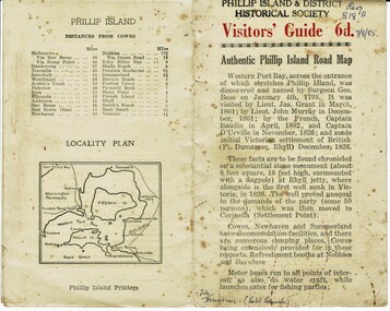
... Road Map Tourist brochure printed by the Phillip Island ...Tourist brochure printed by the Phillip Island Printers pre 1960HistoricalSmall cream coloured brochure with details of accommodation, transport and animals. Inside is a map of the Island with numbered points of interest. There is also a plan of Cowes and drawings of animals.Visitors' Guide 6d Authentic Phillip Island Road Maptourist brochure, road map -
 Melbourne Tram Museum
Pamphlet, Melbourne & Metropolitan Tramways Board (MMTB), "Short Trips around Melbourne and Suburbs by Bus and Tram", mid 1960's
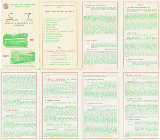
... Trams tramways MMTB Map Tourist Trips Fares Routes Pamphlet ...Pamphlet titled "Short Trips around Melbourne and Suburbs by Bus and Tram", two colour printed document folded into 8 on buff coloured paper, featuring 14 various trips around Melbourne, with a detailed description of each route, time, fare and notes. On reverse side is a detailed map of the MMTB tram and bus routes - from map date document mid to late 1960's - old route numbers eg 4D and Point Ormond and Footscray have closed. See also Reg Item 1508 for an earlier version.trams, tramways, mmtb, map, tourist trips, fares, routes -
Glenelg Shire Council Cultural Collection
Flyer - Flyer - Portland, Victoria, Oct-38
... has tourist map of Portland and District... cover has tourist map of Portland and District Victorian ...Single page flyer, folded 4 times. Tourist information for Portland, issued by Publicity and Tourist Services, Victorian Railways. Contains several black and white photos of Portland, front cover red print, blue stylised bird and sea. Back cover has tourist map of Portland and District -
 Kiewa Valley Historical Society
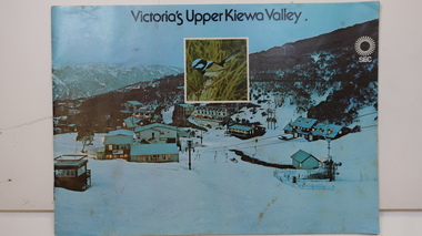
Booklet - SEC x2, 1. Victoria's Kiewa Valley 2. Victoria's Upper Kiewa Valley, No. 2 is dated October 1978
... cover is light green with a tourist map of the area. The text... cover is light green with a tourist map of the area. The text ...The State Electricity Commission of Victoria built the Kiewa Hydro Electric Scheme and was keen to promote tourism in the area. The booklet includes Facilities, Falls Creek Ski Resort, the Kiewa Works Area, the Three Floras of Bogong, the Geology of the Kiewa area, the Bird and Animal life of Bogong and the Kiewa Hydro Electric Scheme. The colored photos and the map on the back appeal to the reader/tourist.The SECV promoted tourism in the Kiewa Valley especially the area of the Kiewa Hydro Electric Scheme. This booklet is attractive and informative with a lot of detail. This proved to be the early stages of tourism in the area in what is now a very popular tourist destination and the main industry for the Upper Kiewa Valley.Blue cover with photo of Falls Creek at night. Title in black print at the centre top under which is an insert photo of a blue wren and SEC logo in white towards the top far right. Back cover is light green with a tourist map of the area. The text is complimented with brightly colored photos throughout.state electricity commission of victoria; kiewa hydro electric scheme; tourism; bogong; flora; fauna; geology;